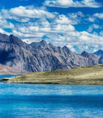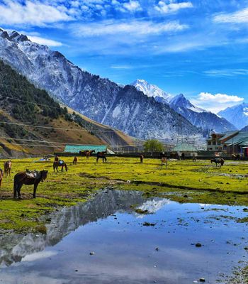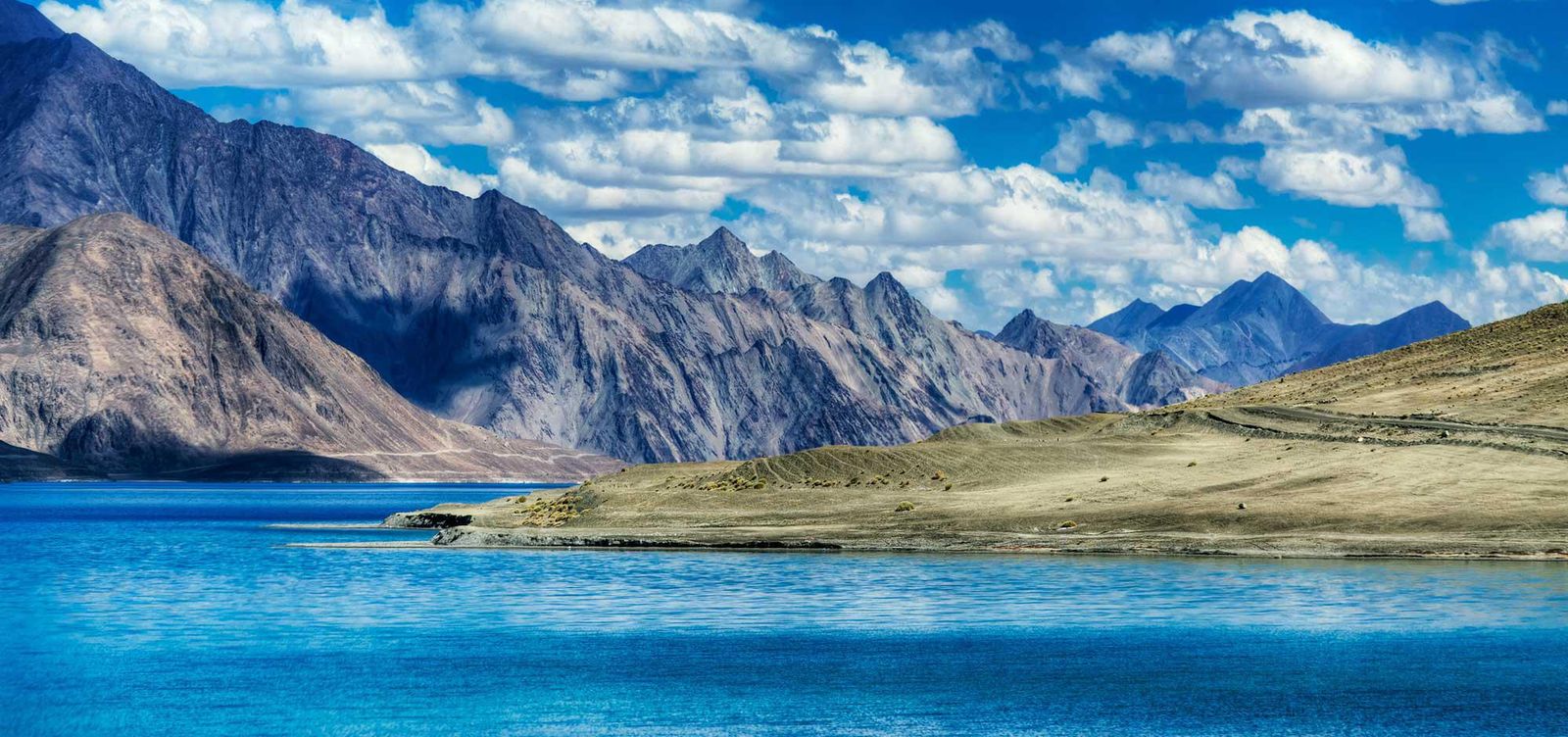
At 14,270 feet above sea level, Pangong Lake doesn't greet you so much as confront you. After five hours on a bone-rattling road from Leh, winding over the Chang La pass where the air thins to the point of mild delirium, you round a final bend and the water appears — an impossible streak of blue cutting across a landscape otherwise devoid of life. No trees line its shore. No birds circle above in any great number. Just the lake, the mountains, and a silence so complete it becomes a sound of its own.
Stretching roughly 134 kilometers from India into China, Pangong is an endorheic lake — no river flows out of it. The water simply stays, evaporates, and stays again. Nearly two-thirds of it lies across the Line of Actual Control in Tibet. You're looking at a geopolitical fault line dressed up as a postcard. That tension between beauty and contested border gives the place a strange, charged quality that no photograph can communicate.
The Water That Can't Decide Its Color
People talk about the color of Pangong Lake the way they talk about the weather — it changes while you're describing it. In early morning, the surface runs a dark, almost marine blue that looks transplanted from the Mediterranean. By midday, sunlight floods the basin and the water turns turquoise, then an eerie pale green near the shallower banks. Clouds drift across; patches of indigo appear and dissolve within minutes.
This chromatic restlessness comes from the lake's depth, its mineral content, and the angle of light bouncing off a barren landscape with nothing green to absorb it. The surrounding mountains are stripped to the bone — rust-colored rock, grey scree, occasional streaks of black basalt. Against this monochrome amphitheater, every shift in the water feels theatrical, as if the place is performing for an audience of one.
Here's the thing that should bother a physicist: Pangong is a saltwater lake, yet it freezes solid in winter. From December through March, the entire surface locks into ice thick enough that locals have historically walked across it. Saltwater doesn't freeze easily. But at this altitude, with temperatures plunging to minus thirty degrees Celsius, the cold simply overpowers the chemistry.
Getting There Without Losing Your Mind
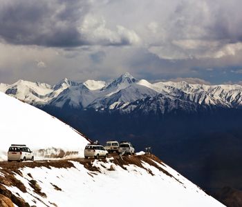
The drive from Leh follows the road over Chang La, one of the highest motorable passes in the world at roughly 17,590 feet. You'll need an Inner Line Permit, obtainable through the District Commissioner's office in Leh or through local travel agents who can process it within a day. Don't skip this. Military checkpoints along the route will turn you back without documentation, and they don't care about your schedule.
Hire a driver in Leh. This is genuinely the smarter choice, not a luxury. The road alternates between smooth tarmac and unpaved gravel where the vehicle lurches sideways toward drops that don't bear contemplating. Your driver will know which sections recently washed out, where military convoys pause, and how to coax a reluctant engine at altitude. Budget five to six hours each way.
Altitude sickness is a real concern, not a footnote. Spend at least two full days acclimatizing in Leh before attempting the drive. Headaches and nausea at Chang La are common even among the prepared. Carry water, Diamox if your doctor prescribes it, and keep your expectations for physical exertion modest once you reach the shore. Walking briskly here feels like climbing stairs with a weighted vest.
Where the Bollywood Fantasy Meets Bare Earth
The 2009 film "3 Idiots" turned Pangong from a remote military-adjacent zone into one of India's most recognizable landscapes. The final scene, shot at the western shore near Lukung, drew millions of domestic tourists who arrived expecting the cinematic version — warm light, two friends reuniting, a tidy emotional resolution against cerulean water.
What they found instead was wind. Relentless, dust-carrying wind that whips off the water and stings exposed skin. The famous yellow scooter from the film has been replicated as a photo prop near the shore, and on busy summer days a queue forms beside it. Vendors sell instant noodles and chai from temporary stalls. The juxtaposition is difficult to ignore — a wilderness that took millions of years to form, now accessorized with a Bollywood prop and Maggi packets.
Walk fifteen minutes in either direction, though, and the circus disappears. The silence returns. You're alone with the water and the wind and the absurd scale of the Changthang plateau stretching eastward into Tibet. Fifteen minutes. That's all it takes to leave the twenty-first century behind.
Sleeping at the Edge of the World
Accommodation near Pangong is spartan by any measure. Camps along the Lukung and Spangmik shoreline offer canvas tents with basic bedding, and on cold nights — which is most nights, even in July — you'll want every blanket they provide. Don't expect running hot water or reliable electricity. A few upgraded camps now advertise heated tents and attached bathrooms, but verify before booking, because the definition of "attached bathroom" varies wildly at 14,000 feet.
Meals at the camps are simple. Dal, rice, chapati, and whatever vegetables survived the drive from Leh. The food is honest rather than memorable. But eating anything at this altitude while watching the lake darken at sunset — the surface going from turquoise to slate in the time it takes to finish a bowl of rice — feels like compensation enough. Carry your own snacks and plenty of water as a backup.
When to Go and What to Accept
The lake is accessible from May through September. June and July offer the warmest conditions, though "warm" here means daytime temperatures around fifteen degrees Celsius. August brings the tail end of the Indian monsoon, which occasionally closes the road with landslides. September delivers clear skies and fewer crowds, but nights turn genuinely cold.
If you're carrying a camera, plan for early morning or late afternoon. Midday sun washes out everything and flattens the lake's famous hues. A polarizing filter helps, but honestly, the naked eye does better work here than most lenses. There's a lesson in that — some places resist being captured and insist on being experienced instead.
One reality to accept before you go: this is a sensitive border area. The Indian Army maintains a visible presence, and certain sections of the shoreline are off-limits. Military vehicles share the road with tourist SUVs, and checkpoints are part of the rhythm of the journey. Pangong isn't simply a scenic destination. It's a place where nations still disagree about where one country ends and another begins, and the landscape carries that weight whether or not you choose to notice it.
Worth Every Difficult Mile
Pangong Lake doesn't make it easy. The road punishes your body, the altitude tests your patience, and the accommodation asks you to abandon most comforts. Yet the lake repays all of this with a single, sustained visual experience that lodges somewhere deep and doesn't leave. Stand at the shoreline as the light shifts from gold to grey, watch the water cycle through its impossible palette, and you'll understand why people endure the journey. Some places earn their remoteness. Pangong has earned every mile of bad road between it and the rest of the world.