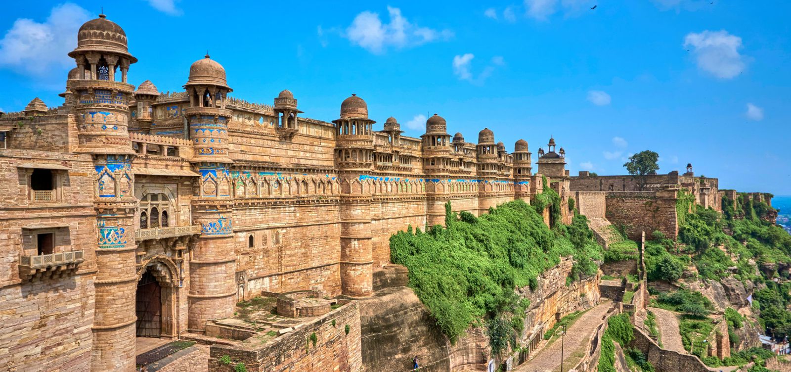
A flat-topped sandstone plateau rises abruptly from the plains of central Madhya Pradesh, and on its back sits a fort so commanding that the Mughal emperor Babur once called it "the pearl amongst fortresses in India." He wasn't being generous. Gwalior Fort earns that description through sheer geological drama — its walls don't climb the hill so much as grow from it, the cliff face and the ramparts becoming indistinguishable at certain angles. The fort stretches nearly three kilometers along the plateau's spine, visible from almost anywhere in the city below, a constant reminder that this was once among the most contested pieces of real estate on the subcontinent. What strikes you on approach isn't the grandeur. It's the stubbornness. This place was built to refuse.
A Palimpsest of Empires
Gwalior Fort doesn't belong to a single dynasty, a single century, or a single architectural grammar. Rajputs, Tomars, Mughals, Marathas, and the British all held it at different points, and each left their mark — one era's palace butting against another's temple, a Mughal courtyard sharing a wall with a Hindu shrine. The coherence here isn't stylistic. It's geological. The sandstone underneath is the only constant.
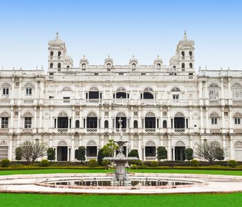
The oldest surviving structures date to the Tomar dynasty in the 15th century, and it's their work that dominates the skyline. Man Singh Palace, raised by Raja Man Singh Tomar between 1486 and 1516, is the fort's visual signature — and nothing quite prepares you for it. Its exterior walls are covered in glazed tile mosaics: ducks, elephants, crocodiles, lotus flowers, rendered in turquoise, yellow, and green against the buff sandstone. From a distance, the palace looks like someone draped a Persian carpet across a cliff face. Up close, the tiles have a rough, handmade unevenness that no photograph captures properly. You have to run your hand near them to believe they're real.
Step inside, and the mood turns cold. The Mughals converted parts of the palace into a prison. Emperor Aurangzeb held his brother Murad here before executing him in 1661. The underground chambers are cool and lightless, a brutal counterpoint to those exuberant tiled facades just meters away. Beauty upstairs, darkness below. That juxtaposition tells you more about the fort's history than any plaque could.
Where Gods and Conquerors Share the Rock
Along the southeastern approach, enormous Jain sculptures carved directly into the cliff face between the 7th and 15th centuries confront you before you even reach the gates. There's no easing into it. The largest figure, a representation of the first Tirthankara Adinatha, stands over 17 meters tall — serene, implacable, watching you climb. Mughal emperor Babur ordered several of these sculptures defaced during his conquest; some faces were chiseled away entirely, though many were later restored. The scars remain visible on a few figures if you look carefully, a record of iconoclasm preserved alongside devotion. The damage and the repair coexist, and nobody has tried to smooth that contradiction over.
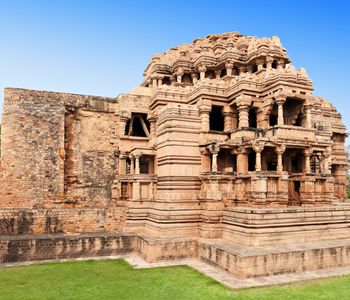
Inside the fort complex, the Teli ka Mandir rises to roughly 30 meters, making it the tallest structure on the plateau. Its architectural style confuses even scholars: a Dravidian barrel-vaulted roof sits atop a North Indian temple base, as if two buildings from opposite ends of the subcontinent were fused mid-construction. The temple dates to the 8th century and was dedicated to Vishnu, though it was later repurposed as a soda-water factory by the British. Let that sink in. A soda-water factory. In an 8th-century temple to Vishnu. Empire, in a single detail.
The Sas-Bahu temples, dating to the 11th century, are a different kind of excess — every surface encrusted with figures, floral motifs, and geometric patterns so dense your eye can't settle. Despite the popular folk etymology linking the name to "mother-in-law and daughter-in-law," it actually derives from Sahastrabahu, meaning the thousand-armed form of Vishnu. The carving here has the obsessive quality of someone who feared blank space the way others fear heights.
An Approach That Makes You Work
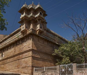
Two gates offer entry to the fort. The northeastern gate, known as the Gwalior Gate, involves a steep, winding road that vehicles can navigate — functional, efficient, forgettable. The western approach through the Urvai Gate is steeper and far more rewarding. You climb on foot past those colossal Jain carvings, the rock walls pressing close on either side, the fort slowly revealing itself above you in fragments. Choose this route if your knees allow it. The experience of ascending through carved rock gives you a visceral understanding of what attackers faced — and why so many of them failed.
The fort sits at roughly 100 meters above the surrounding city. That doesn't sound dramatic on paper, but the sandstone cliff is nearly vertical on all sides. Six gates once defended the approach, and remnants of each survive. By the time you pass through the final gate and step onto the plateau, you've earned what comes next — Gwalior sprawling below, the Tomar palaces ahead, the wind carrying sound differently at this elevation. The city feels like another country down there.
What You Need to Know Before You Go
The fort complex opens at sunrise and closes at sunset. A sound-and-light show runs in the evening at the Man Singh Palace amphitheater — the Hindi version typically screens first, followed by an English version. It's broad in its storytelling but useful for orienting yourself to the fort's tangled timeline before exploring the grounds the next morning.
Entry fees are modest: Indian nationals pay around 75 rupees, while international visitors pay 250 rupees. Separate tickets apply for the museum inside the Gujari Mahal at the base of the fort, which houses a small but genuinely worthwhile collection of Hindu and Jain sculptures recovered from the region. Don't skip it simply because it's at the bottom of the hill.
Gwalior city connects to Delhi by rail in about three to four hours on the Shatabdi Express, making it feasible as a long day trip from the capital — though the fort deserves an unhurried morning at minimum. Auto rickshaws from Gwalior railway station reach the fort's base in fifteen minutes. The months between October and March offer the most tolerable conditions. Summer temperatures regularly exceed 45 degrees Celsius, and the exposed plateau offers almost no shade. This is not a detail to be brave about.
Bring water. Wear sturdy shoes. The plateau's surface is uneven sandstone, and you'll cover more ground than you expect moving between the temples, palaces, and gates scattered across the complex.
The Fort That Outlasted Every Flag Raised Over It
Gwalior Fort changed hands more than a dozen times across its documented history. Rajputs lost it to Sultanates, who lost it to Mughals, who lost it to Marathas, who lost it to the British, who eventually handed it back to India. Each conqueror found the fort worth seizing and impossible to dismiss. Here's the counterintuitive thing: the fort's greatness isn't in any single dynasty's contribution. It's in the accumulation — the way each ruler added something, defaced something else, and still couldn't bring themselves to abandon the plateau. That relentless cycle of conquest speaks to something deeper than strategy. It was symbolic. Standing on the plateau's edge, looking down at the city that grew in its shadow, you understand why no one who held Gwalior Fort ever gave it up willingly. The rock wouldn't let them.